Two Quakes In One Minute: What Caused Venezuela’s Deadly Earthquakes
Two Quakes In One Minute: What Caused Venezuela’s Deadly Earthquakes Published By, Last Updated: June 25, 2026, 14:54 IST The twin earthquakes have killed at
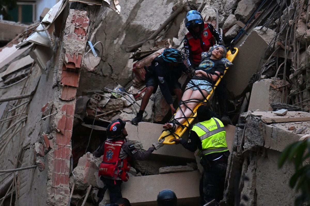
Two Quakes In One Minute: What Caused Venezuela’s Deadly Earthquakes Published By, Last Updated: June 25, 2026, 14:54 IST The twin earthquakes have killed at least 32 people and injured more than 700, with La Guaira described as the hardest-hit region. Rapid Read Venezuela declared a state of emergency after two powerful earthquakes struck the country within about a minute, killing at least 32 people and injuring more than 700. (AFP) Venezuela declared a state of emergency after two powerful earthquakes struck the country within about a minute, killing at least 32 people and injuring more than 700. The magnitude 7.2 and 7.5 earthquakes hit shortly after 6 pm local time on Wednesday, damaging buildings, roads and essential services across several states. Acting President Delcy Rodríguez warned that the toll was expected to rise as rescuers searched collapsed structures and reached areas cut off by the disaster. The initial casualty figures did not include La Guaira, north of Caracas, which Rodríguez described as a “disaster zone" and the worst-affected region. “Dozens of buildings have collapsed there, about 30 kilometers (19 miles) north of Caracas, and we are currently carrying out intensive rescue operations to save lives," she said. The earthquakes were among the strongest to hit Venezuela in more than a century. Their timing, shallow depth and location near a major tectonic boundary help explain why the shaking was so intense and widespread. Where Did The Earthquakes Strike? According to the US Geological Survey, the first earthquake, measuring magnitude 7.2, struck west of Morón on Venezuela’s Caribbean coast, about 168 kilometres west of Caracas. It originated at a depth of approximately 22 kilometres. A magnitude 7.5 earthquake followed about a minute later. The second quake was shallower, originating at a depth of around 10 kilometres, with its epicentre about 16 kilometres southwest of Morón. Although the epicentres were outside Caracas, the tremors were strongly felt in the capital and across central and western Venezuela. Shaking was reported in Carabobo, Miranda, La Guaira, Falcón and Trujillo. The earthquakes were also felt in parts of Colombia and in Brazil’s Amazon region, more than 1,700 kilometres from Caracas.
Buildings were evacuated in the Brazilian cities of Manaus, Belém and Macapá. The US Pacific Tsunami Warning Center issued several alerts after the earthquakes, but later said there was no tsunami threat. What Caused The Venezuela Earthquakes? Venezuela lies near the boundary between the Caribbean and South American tectonic plates. The Earth’s outer surface is divided into large slabs known as tectonic plates, which move slowly over time. Where two plates meet, their movement creates stress in the surrounding rocks and along fractures in the Earth’s crust called faults. The USGS said the second and larger earthquake was caused by “shallow strike-slip faulting" near the boundary between the Caribbean and South American plates. Strike-slip faulting occurs when two sections of the Earth’s crust move horizontally past one another. The movement is sideways rather than one plate being forced sharply beneath another. Faults do not always move smoothly. Friction can hold parts of a fault in place even as the surrounding plates continue to shift. This causes pressure to accumulate underground. When that pressure becomes too great, the locked section of the fault suddenly slips, releasing energy in the form of seismic waves. Those waves travel through the ground and produce the shaking felt during an earthquake. Why Did Two Large Earthquakes Strike Within A Minute? The two earthquakes may have been part of the same complex fault movement. According to the USGS, the first quake may have shifted pressure along the fault and triggered another section to break almost immediately. The USGS said the sequence “likely indicates a complex, rupture interaction process". It also explained that large earthquakes do not occur at a single pinpoint location. Although maps show an epicentre, the actual rupture can spread across a much larger section of a fault. “While commonly plotted as points on maps, earthquakes of this size are more appropriately described as slip over a larger fault area," the USGS said. The two recorded quakes may therefore represent linked movements across different parts of the same fault system. Why Was The Shaking So Destructive? Both the strength and depth of the earthquakes increased the danger.