Where Did Monsoon Go? Why A Rare June Pause In Central And Western India Has Weathermen Worried
Where Did Monsoon Go? Why A Rare June Pause In Central And Western India Has Weathermen Worried Published By, Last Updated: June 17, 2026, 11:57
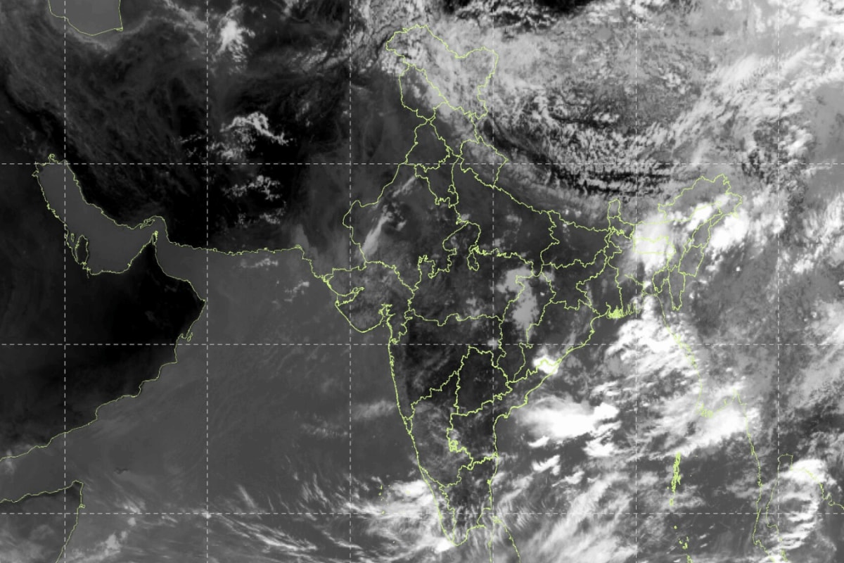
Where Did Monsoon Go? Why A Rare June Pause In Central And Western India Has Weathermen Worried Published By, Last Updated: June 17, 2026, 11:57 IST Fresh satellite images show large parts of central, western and peninsular India are missing the dense cloud bands normally associated with an active monsoon. Rapid Read The satellite map on the IMD website shows almost no clouds over central and northwestern India. (Image: IMD) Just days ago, India’s southwest monsoon appeared to be racing ahead of schedule. Today, satellite images are showing something entirely different: vast swathes of the country with barely any monsoon cloud cover. Fresh imagery from European weather satellite Meteosat, US weather agency NOAA and ISRO’s INSAT-3DS satellite has revealed an unusual picture for mid-June – large parts of central, western and peninsular India are missing the dense cloud bands normally associated with an active monsoon. The images have become the most visible symbol of what meteorologists are calling a significant pause in the monsoon’s advance. The slowdown has already translated into worrying numbers on the ground. According to the India Meteorological Department (IMD), Central India recorded a rainfall deficit of around 65 per cent between June 4 and June 16, making it the worst-hit meteorological region in the country. Several districts across Maharashtra, Madhya Pradesh, Chhattisgarh and adjoining areas have received little or no meaningful monsoon rainfall during a period that is crucial for kharif sowing. A Monsoon That Started Strong The current pause is particularly striking because the season began with remarkable speed. The southwest monsoon officially reached Kerala on June 4, three days later than the normal onset date of June 1.
Within days, it advanced rapidly over large parts of southern India, the Arabian Sea and the Bay of Bengal region. By the second week of June, the monsoon had covered Kerala, Tamil Nadu, Karnataka, Goa, parts of Maharashtra, Telangana, Andhra Pradesh, Odisha, West Bengal, Bihar and much of the Northeast. Then, it stalled. Weather reports indicate that the monsoon’s northern and western advance has remained largely frozen for over a week. In Maharashtra, the monsoon has been stuck around the Solapur region since June 8. Vidarbha, which usually expects monsoon arrival by around June 15, is still waiting, while parts of Uttar Pradesh are now expected to receive monsoon five to ten days later than normal. Where Is Monsoon Now? As of mid-June, monsoon has covered most of southern India and eastern India but has struggled to push deeper into central and northwestern parts of the country. The delay is being felt across Vidarbha, large parts of central Maharashtra, sections of Madhya Pradesh, and parts of north India. Lucknow, which normally sees monsoon onset around June 23, is expected to receive it only towards the end of June or early July. Similar delays are being watched in neighbouring regions of Uttar Pradesh and central India. Meteorologists currently expect the next significant phase of monsoon advancement only during the latter half of June if favourable weather systems develop over the Bay of Bengal. Why Has Monsoon Suddenly Slowed? The biggest reason is the absence of strong low-pressure systems over the Bay of Bengal. Normally, June witnesses the formation of low-pressure areas that act as engines for monsoon circulation. These systems pull moisture inland and help the monsoon move westward and northward.