Heavy Showers Ahead? Massive 10,000-Km Rain Band Spotted Stretching Across North India
Heavy Showers Ahead? Massive 10,000-Km Rain Band Spotted Stretching Across North India Published By, Last Updated: July 23, 2026, 10:57 IST The latest spell is
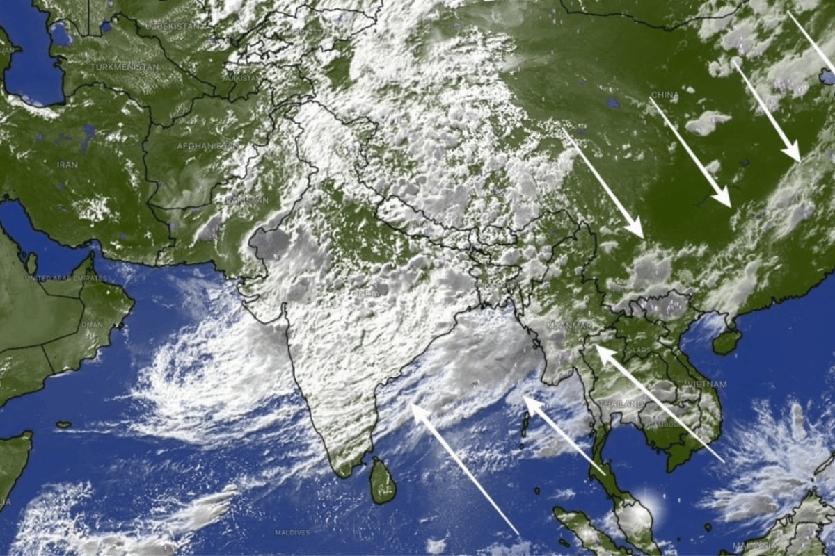
Heavy Showers Ahead? Massive 10,000-Km Rain Band Spotted Stretching Across North India Published By, Last Updated: July 23, 2026, 10:57 IST The latest spell is expected to improve India's seasonal monsoon performance after an erratic start left several regions facing rainfall shortages. Massive cloud band seen covering India. (Source: Windy) A massive 7,000-10,000-kilometre-long rain band stretching from north India across the Himalayas, China and up to South Korea has been captured in the latest satellite imagery, signalling one of the most active phases of the 2026 southwest monsoon and raising the likelihood of widespread rainfall over large parts of the country in the coming days, according to a report published by India Today. The formation of the vast cloud band, known as a monsoon convergence zone, has taken place as moisture-laden winds from the Indian Ocean continue to interact with weather systems across Asia. This interaction has created a broad corridor of clouds and rainfall, allowing rain clouds to continuously regenerate over thousands of kilometres. Also Read: Mumbai, Thane On Heavy Rain Alert; Palghar Declares School Holiday: Top 10 Updates The atmospheric feature has coincided with an intense burst of monsoon activity in India.
Over the past two days, rainfall across the country has been estimated at 170-180% above the normal daily average, making it the strongest monsoon phase recorded so far this season, as per India Today. States including Uttar Pradesh, Uttarakhand, Punjab, Haryana, Rajasthan and the Delhi-NCR region have already witnessed heavy showers, while low-pressure systems over the Bay of Bengal continue to fuel intense rainfall across eastern and northeastern India. The latest spell is expected to improve India’s seasonal monsoon performance after an erratic start left several regions facing rainfall shortages. Meteorologists believe the ongoing wet phase could narrow the rainfall deficit considerably over the coming days, especially across north and central India, while also boosting water storage and providing much-needed moisture for kharif crops. Despite the welcome relief, officials are keeping a close watch on the potential risks associated with prolonged heavy rainfall. Forecasts indicate that the active monsoon phase is likely to persist through the week, increasing the possibility of flash floods, urban waterlogging, landslides and rising river levels, particularly in the Himalayan states of Uttarakhand and Himachal Pradesh.
Also Read: Assam Flood Death Toll Rises To 50: Heavy Rain Forecast Keeps Situation Grim Experts say the satellite images also offer a reminder that India’s monsoon is part of a much larger weather engine operating across Asia. Rather than being confined to the subcontinent, the current circulation stretches thousands of kilometres eastward, connecting weather systems from the Arabian Sea to East Asia and influencing rainfall across several countries simultaneously. News18 Newsletter Handpicked stories, in your inbox A newsletter with the best of our journalism submit Key Questions Answered Will this heavy rainfall alleviate India's water shortages? The current heavy rainfall is expected to improve India's seasonal monsoon performance after an erratic start. A massive 7,000-10,000-kilometer-long rain band has been observed, signaling active monsoon phases and widespread rainfall. What are the potential risks of this prolonged monsoon activity? Potential risks of prolonged monsoon activity include waterlogging and floods in isolated pockets, flash floods, landslides, and travel disruptions. Intense rainfall can also trigger mudslides and rockfalls, particularly in vulnerable hill districts. How does this rain band affect other Asian countries?
 The BriefWire